Log in
All resources
Create a design
34,416 Free Images of No Edit
maps from the earth and its inhabitants, vol. iv
hubert-françois gravelot
illustration of decameron, edition londres 1757
engraving
bibliothèque nationale de france
maps from the earth and its inhabitants, vol. vii
rococo
maps from the earth and its inhabitants, vol. xiv
germany
wanfried
maps from the earth and its inhabitants, vol. vii
1870s maps of japan
the lands of scripture (1879)
architecture bl
maps from the earth and its inhabitants, vol. vii
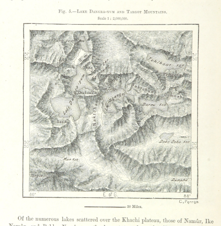
targot mountains
maps from the earth and its inhabitants, vol. xiii
mount kenya
maps from the earth and its inhabitants, vol. iv
19th-century maps of cornwall
maps from the earth and its inhabitants, vol. iv
1870s maps of scotland
maps from the earth and its inhabitants, vol. xiv
exploration of australia
maps from the earth and its inhabitants, vol. viii
maps of the mekong
19th-century maps of sierra leone
maps of rivers of sierra leone
illiteracy in france
education in france
maps from the earth and its inhabitants, vol. iii
population density maps of germany
maps from the earth and its inhabitants, vol. iv
sewers in london
maps from the earth and its inhabitants, vol. viii
ghats
germany
flower
people
city
celebrities
city
landscape
nature
architecture
germany
album del ferrocarril mexicano
railway bridges in mexico
bland tomtar och troll (among gnomes and trolls) 1912 edition
trollkarlens kappa
album del ferrocarril mexicano
valley of mexico
bland tomtar och troll (among gnomes and trolls) 1913 edition
tomtar
john tenniel's illustrations of alice's adventures in wonderland
cheshire cat
finland framstäldt i teckningar
pehr kruskopf
art works by daniel urrabieta vierge
engravings of maison de victor hugo
art works by daniel urrabieta vierge
drawings of maison de victor hugo
maps from the earth and its inhabitants, vol. xvi
ethnographic maps of north america
maps from the earth and its inhabitants, vol. xi
1870s maps of tunisia
maps from the earth and its inhabitants, vol. iii
maps of the sava watercourse system
maps from the earth and its inhabitants, vol. vii
linguistic maps of chinese languages
maps from the earth and its inhabitants, vol. xi
roads in tunisia
maps from the earth and its inhabitants, vol. ix
population density maps of the ottoman empire
fashion and costumes from the british library mechanical curator collection
illustrations by william small
maps from the earth and its inhabitants, vol. xvii
maps of native american tribal territories
maps from the earth and its inhabitants, vol. xvii
old maps of washington, d.c.
maps from the earth and its inhabitants, vol. viii
precipitation maps
maps from the earth and its inhabitants, vol. xiv
1870s maps of indonesia
maps from the earth and its inhabitants, vol. iv
queensferry crossing
maps of rivers of south sudan
sobat river
maps from the earth and its inhabitants, vol. iv
portskewett
maps from the earth and its inhabitants, vol. iv
bathymetric maps of the north sea
maps from the earth and its inhabitants, vol. iv
maps of balmoral castle
maps from the earth and its inhabitants, vol. vii
19th-century maps of korea
maps from the earth and its inhabitants, vol. xviii
maps of the indigenous peoples of south america
maps from the earth and its inhabitants, vol. iv
cirencester
fleurons from the earth and its inhabitants, vol. ix
1878 fleurons
maps from the earth and its inhabitants, vol. iii
1870s maps of switzerland
maps from the earth and its inhabitants, vol. iv
old maps of windsor
maps from the earth and its inhabitants, vol. vii
1870s maps of china
maps from the earth and its inhabitants, vol. iv
maps of tides
maps from the earth and its inhabitants, vol. xvi
maps of the history of mexico
maps from the earth and its inhabitants, vol. iv
19th-century double hemisphere world maps
maps from the earth and its inhabitants, vol. iv
old maps of dover, kent
maps from the earth and its inhabitants, vol. xvii
french louisiana
maps from the earth and its inhabitants, vol. iv
old maps of hastings, england
maps from the earth and its inhabitants, vol. xiv
1870s maps of indonesia
maps from the earth and its inhabitants, vol. viii
maps of the mekong
maps from the earth and its inhabitants, vol. iv
1870s maps of london
maps from the earth and its inhabitants, vol. xviii
old maps of valparaíso
maps from the earth and its inhabitants, vol. xiii
old maps of luanda
maps from the earth and its inhabitants, vol. iv
old maps of sheffield
maps from the earth and its inhabitants, vol. iv
eddystone rocks, devon
maps from the earth and its inhabitants, vol. iv
old maps of leeds
maps from the earth and its inhabitants, vol. v
ringkjøbing
maps from the earth and its inhabitants, vol. vi
charles eugène perron
maps from the earth and its inhabitants, vol. iv
maps of falmouth, cornwall
maps from the earth and its inhabitants, vol. vii
yarlung tsangpo
maps from the earth and its inhabitants, vol. iv
public transport maps of london
maps from the earth and its inhabitants, vol. x
hannek
maps from the earth and its inhabitants, vol. x
lake tana
maps from the earth and its inhabitants, vol. iv
old maps of the isle of arran
maps from the earth and its inhabitants, vol. xi
maps indicating exploration
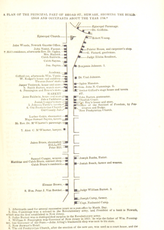
historical collections of the state of new jersey (1852)
maps of newark, new jersey
maps from the earth and its inhabitants, vol. vi
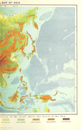
topographic maps of asia
maps from the earth and its inhabitants, vol. xv
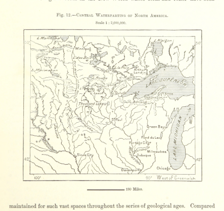
hydrological maps of the united states
maps from the earth and its inhabitants, vol. xviii
1870s maps of peru
maps from the earth and its inhabitants, vol. xvii
linguistic maps of north america
maps from the earth and its inhabitants, vol. xiv
old maps of sydney
maps from the earth and its inhabitants, vol. xviii
south america in the 19th century
maps from the earth and its inhabitants, vol. vii
charles eugène perron
maps of ardabil province
maps of sabalan
maps from the earth and its inhabitants, vol. xiii
1878 maps of africa
maps from the earth and its inhabitants, vol. xviii
maps of weather and climate of south america
maps from the earth and its inhabitants, vol. iv
precipitation maps
maps from the earth and its inhabitants, vol. xvi
jorullo
maps from the earth and its inhabitants, vol. iv
old maps of leeds
maps from the earth and its inhabitants, vol. iv
snaith
jacques aliamet
rococo
illustration of decameron, edition londres 1757
hubert-françois gravelot
illustration of decameron, edition londres 1757
hubert-françois gravelot
illustration of decameron, edition londres 1757
rococo
hubert-françois gravelot
rococo
illustration of decameron, edition londres 1757
rococo
illustration of decameron, edition londres 1757
hubert-françois gravelot
hubert-françois gravelot
rococo
illustration of decameron, edition londres 1757
rococo
colette - les vrilles de la vigne - kra 1930
rené lelong
dictionnaire populaire illustré de décembre-alonnier-tome 1
sack of berwick (1296)
le mystérieux docteur cornélius
posters by julien t' felt
viala et vermorel
alexis kreyder
20401 - 20500 of 34,416
Next page
/ 345